The 2020 UDCPR is back in effect
The 2020 Unified Development Control and Promotion Regulations (UDCPR) are now in force. These regulations were scrapped shortly after introduction and reverted to the 2018 DCPR. A government notification dated 15 July 2026 has restored the UDCPR with amendments.
Beyond standard legal due diligence, we highly recommend a second layer of diligence on development potential with the relevant governing body. For Pawna, that is the PMRDA (Pune Metropolitan Region Development Authority). The Maharashtra Remote Sensing Application Centre and the state's cadastral map portal, both linked at the bottom of this page, make this task considerably easier.
Slope and access
Two site requirements decide whether land can be developed at all: slope and access.
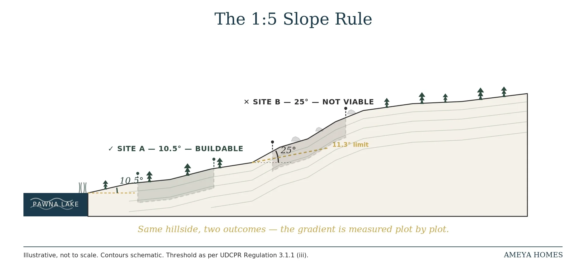
Any site with a gradient greater than 1:5, roughly 11.5 degrees, is ineligible for development. Most of the prime hillside plots with extensive lake views sit at or beyond this threshold, which makes slope a critical filter before you fall for a view.
Access has its own minimum: 6 metres (20 feet) of road width for farm or forest houses, rising to 9 metres (30 feet) in some cases, such as holiday homes. This usually becomes a problem when a plot does not abut a designated government road and access instead runs through private property. Buyers who don't confirm the required access width before purchase often find themselves negotiating from a position of weakness when they try to acquire the additional strip of land afterward. Our plot selection guide covers the specific access check to run, including a real example from Pawna's own ring road.
Distance from the high tide line
No development is permitted within 100 metres of the lake's high tide line. Lake levels shift visibly across seasons, but what governs development potential is the plot's distance from the high tide line as recorded on government plans, not what the shoreline looks like on the day you visit. Anyone drawn to a lake-touching property should factor this in before making an offer.
The zones around the lake
The vast majority of land around Pawna Lake falls into one of four zones:
| Zone | Development status |
|---|---|
| Forest | No-development, reserved for conservation, regulated by MOEF |
| Hill Slope | No-development, reserved for conservation, regulated by MOEF |
| Afforestation | Forest, farm, or tourist homes permitted, subject to plot size |
| Agriculture / Green Zone 1 | Forest, farm, or tourist homes permitted, subject to plot size |
Forest and Hill Slope are essentially no-development zones reserved for conservation. Any activity within them is regulated by the Ministry of Environment, Forest and Climate Change (MOEF).
For a second-home buyer, Afforestation and Agriculture zones are functionally identical. Both permit forest, farm, and tourist homes:
What this means for a buyer
A plot is worth pursuing only if it clears four tests: the right slope, the right access, 100 metres or more from the high tide line, and the right zone.
There is one exception worth flagging: land within Gaothan limits, currently defined around Pawna as within 200 metres of an existing Gaothan boundary. This carries its own development rules, which we'll cover in a future guide.
For the full sequence of checks to run once a plot has cleared these four tests, see 11 Checks That Save You The Trip.
Useful links
- Notification & 2020 UDCPR — shorturl.at/QCXUZ
- Maharashtra Remote Sensing Application Centre — geoportal.mrsac.org.in
- Cadastral maps with land records — mahabhunakasha.mahabhumi.gov.in
- PMRDA — Pune Metropolitan Region Development Authority — pmrda.gov.in