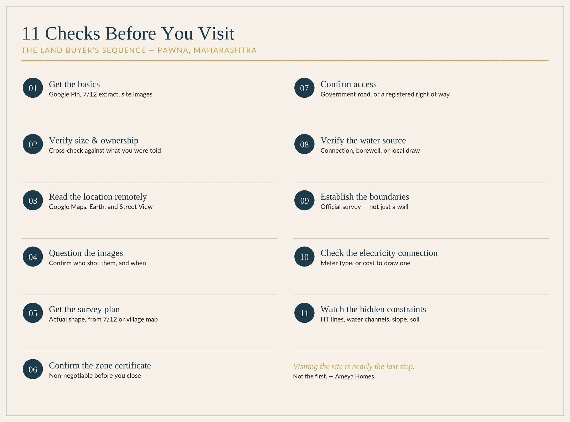
Here is where most buyers get the sequence backwards. Visiting the site feels like the obvious first step. In our process, it's nearly the last.
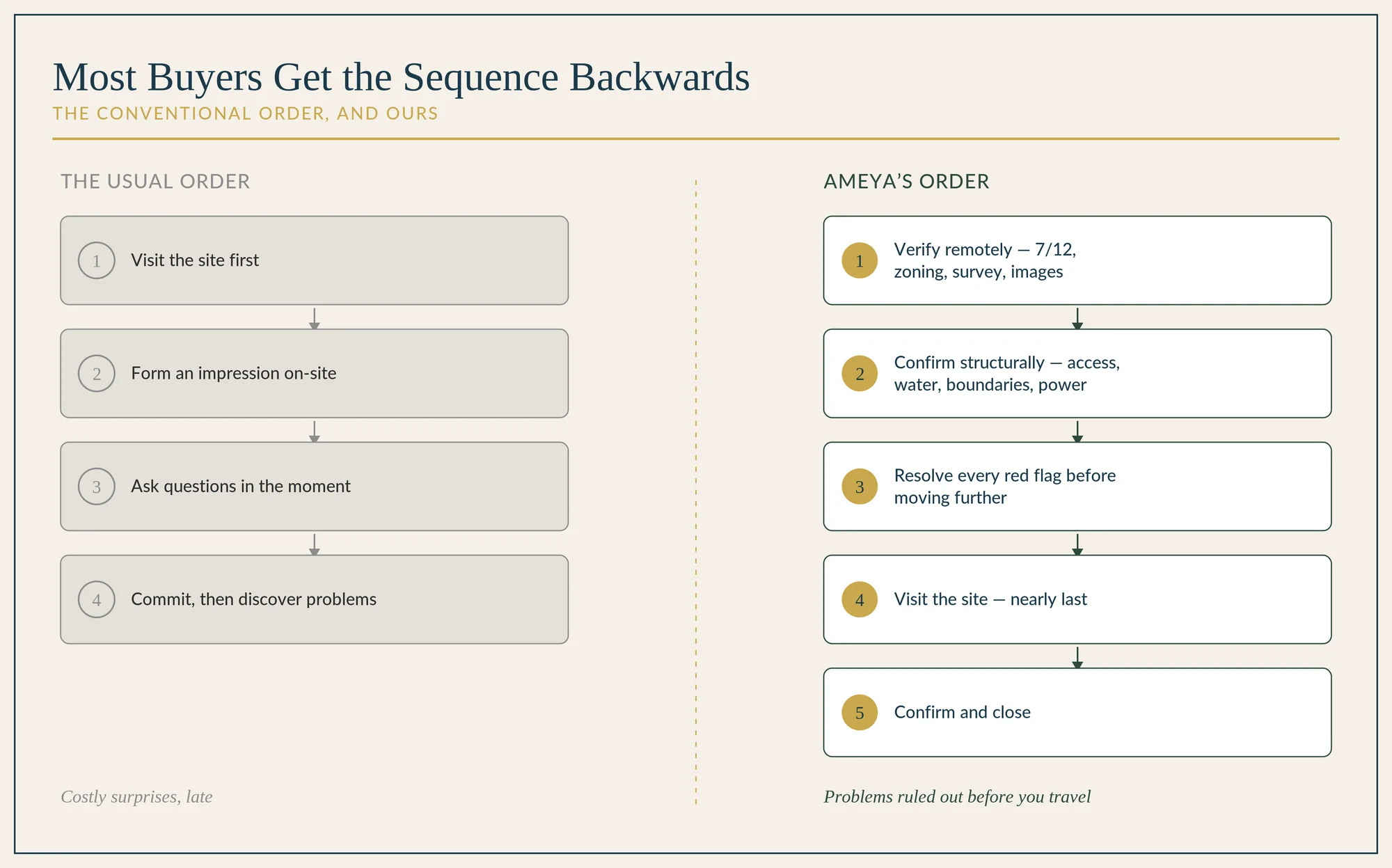
We'll skip the reasoning behind location selection and start from the point where you've picked an area and are evaluating specific plots.
Before you begin
This is written with Pawna in mind, but most of it applies to buying land anywhere in Maharashtra, and across India.
Most of India's land is technically agricultural. Under India's colonial-era land laws, land is classified agricultural by default. Town planning zoning and each state's land revenue code determine whether it can be converted to non-agricultural (NA) use: residential, commercial, or industrial. For practical purposes, treat every plot as agricultural until you have proof of conversion.
This matters because Maharashtra, like many states, restricts agricultural land purchase to agriculturists. If you, your parents, your grandparents, or your spouse (before marriage) have never held agricultural land anywhere in India, you are not eligible to buy it directly. There is a well-known workaround: buy a small parcel, as little as 1 Gunta or 1,000 sq. ft, in a state without this restriction, and that holding qualifies you. This loophole has existed for as long as we can recall.
This restriction isn't limited to one group. NRIs and OCIs can freely buy residential or commercial land, but agricultural land, plantations, and farmhouses are off-limits to them too, without specific RBI approval. Foreign nationals who are neither NRIs nor OCIs face a harder line: under FEMA, they generally cannot buy any immovable property in India at all, agricultural or otherwise, outside inheritance or specific RBI clearance. For that group, the fix isn't "buy NA land instead." It's largely off the table.
If you're working through a broker or intermediary, confirm they have direct access to the owner. Every extra link in the chain corrupts information and raises the odds of a deal falling apart.
The eleven checks
Get the basics first
Ask for the Google Pin, the 7/12 extract, and site images before anything else.
Verify plot size and ownership
Cross-check the plot area and ownership against what the broker or owner told you. Discrepancies here are the most common early red flag.
Understand the location remotely
Google Maps and Google Earth do most of this work before you ever visit.
- What surrounds the plot, and is proximity to a water body a liability or an asset for your intended use?
- What structures, if any, sit nearby?
- Use Street View where it's available.
- How is the plot currently accessed, and what's the actual distance from the locations you care about?
Study the images, and question them
Site images carry more information than most buyers extract from them. Before you trust what you see, confirm who took the photos and when.
Get the survey plan
Request a government survey plan, or pull a village map from the 7/12 record. This tells you the plot's actual shape and whether it's viable to develop.
Rectangular or square plots are always preferable. An irregular shape might suit your current plans, but regular plots hold value better over time. Optionality compounds.
Ask for the zone certificate
Confirm the land falls in a zone you're comfortable with. If the certificate isn't available yet, get an independent zoning check done in parallel. Make this a non-negotiable part of your due diligence before you close. See our zoning and legal guide for what the zones around Pawna actually mean.
Confirm how access actually works
Establish whether access is via a government-sanctioned road or private property.
If it's a government or village road, check the road's designated width against its actual width on the regional plan or at the town planning office. The two are often different.
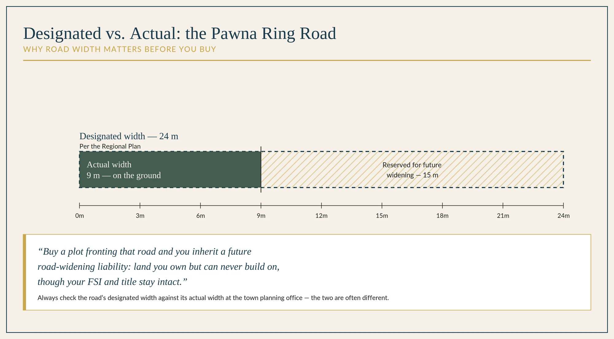
Buy a plot fronting that road and you inherit a future road-widening liability: land you own but can never build on, though your FSI and title stay intact.
If access runs through private property, find out exactly who owns that access strip. Confirm the right of way will be registered and in writing, matched to the width your zone and development type require. Account for more width than the minimum. Never buy on the promise that access will materialize later.
Verify the water source
Is there an existing water connection from a local body, and is the supply enough for what you plan to build?
If not, is a borewell an option? If you're relying on one as your primary water source, it's worth paying for, or reimbursing the owner for, a test bore before you commit, as proof water exists on site.
If neither works, can you draw from a local source? This usually means additional permits for underground piping, which can be costly and time-consuming. Water is not a detail. Don't proceed without a workable answer.
Establish the physical boundaries
Is there an existing compound wall or fence? If there is, that's good. But a compound wall is not proof of the correct boundary. Only an official government survey, which requires notifying every adjoining landowner, confirms where your plot actually ends. A private survey does not carry the same weight.
If there is no existing boundary, or at the very least official government survey markings, we wouldn't waste our time even visiting, because you will never be able to confirm where the property actually sits.
Check the electricity connection
Is there a connection on site with a working meter, and if so, what type: agricultural, residential, or other?
If not, find the nearest point you could draw a connection from, and get an MSEB consultant to estimate the cost. This may be substantial depending on distance.
Watch for the less obvious constraints
- High-tension towers and lines carry mandatory setbacks. No development is permitted within them.
- Water channels marked on village or government maps carry setbacks too, with a no-development buffer on either side.
- Slope matters, especially in hill terrain like Pawna. No development is permitted on gradients steeper than 1:5 — see our zoning and legal guide for the full rule.
- Soil quality is visible in the vegetation before you test it. Stay away from rocky or barren land. Get a soil test done, and a good-for-construction report, before you commit further.
Visiting the site is nearly the last step. Not the first.
Useful links
- FEMA / RBI rules on property acquisition by NRIs, OCIs, and foreign nationals — mea.gov.in
- Mahabhulekh — Maharashtra's official 7/12 and land records portal — bhulekh.mahabhumi.gov.in
- PMRDA — Pune Metropolitan Region Development Authority — pmrda.gov.in
- Google Earth — earth.google.com
- Maharashtra Remote Sensing Application Centre (MRSAC) — mrsac.gov.in
- Mahabhunaksha — Maharashtra's official cadastral map portal — mahabhunakasha.mahabhumi.gov.in